Lisdoonvarna's other claim to fame is the Matchmaking Festival: the town employs and honest-to-god matchmaker (the family vocation for generations), and the festival brings in big crowds by rural Irish standards (ten thousand visitors to a town of nine hundred). We spent Friday night in Lisdoonvarna at the town's one hostel. There we met a South African, a Canadian, and an Oregonian. All were quite friendly––you never meet locals in hostels!
But the most important part of our visit was the walk from Lisdoonvarna to Ballyvaughan along the Burren Way trail. The Burren, I should explain, is a unique geological formation characterized mainly by tons of exposed limestone. And I mean tons. As an added bonus, it's on the Atlantic coast and offers some nice sea views too.
 The countryside around Doolin. You can see the Cliffs of Moher in the distance.
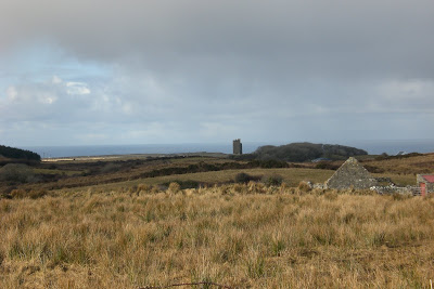
Portions of the Burren Way was along a Green Road, or Famine Relief Road. As you can guess, this route was built to make it easier to get supplies into the countryside during the Potato Famine. Many famine-era farm ruins greet the hiker along this route:

Oh, and that limestone. The Burren is all about "clints" and "grykes." The clints are the large flat slabs of rock (the region was a tropical seabed millions of years ago), and the grykes are the large––and sometimes very deep––gaps in the limestone.

When you really get into the heart of the region, it's stone as far as the eye can see:

The Burren Way turned out to be longer than we calculated: the hike from Lisdoonvarna to Ballyvaughan was about eighteen miles. But all for the better, really. With the scenery as impressive as it was, we didn't want the journey to end. That said, we were a bit sore the next day...
Hiking adventures aside, not too much has changed in the Era of the Warehouse. Our training for volunteer work is nearly complete, and in the coming weeks we should be out in the field. We will be doing home visits with the impoverished for the Society of St. Vincent de Paul, the purpose being that home visits help the Society determine how much assistance a person or family needs.
We probably won't leave Cork again until our trip to Edinburgh, Scotland, at the end of this month. Until then, back to the boxes!

The rock beds are amazing...I've never seen anything like that. No shortage of stone for roads, fences, buildings, etc., I see. The rocks that are sticking up, is that a natural phenomenon? And I wondered also what the triangular stone structure in the first picture is, do you know?
ReplyDeleteReally cool pics, thanks so much for all these posts!
The standing rocks are the work of passing walkers, I'm afraid. It's irresistible to jar some clints loose and stick them in a gryke. The triangular structure is the gable of a stone farm house ruin. If you click on the photos you should be able to see a blown-up version.
ReplyDeleteGreat pics! The landscape is incredible!
ReplyDeleteMore like... the Borin'! Just kidding with you, nice pictures.
ReplyDelete